Category: Uncategorized

  • Use of Artificial Intelligence at Aplitop

    Use of Artificial Intelligence at Aplitop

    Innovation and Commitment to R&D&I

    At Aplitop, innovation is not just a goal, but a strategic pillar. Our commitment to research, development and technological innovation (R&D&I) translates into more efficient, intelligent tools that are aligned with the real needs of the sector.

    First Steps: AI in the tcp PointCloud Editor

    One of the most innovative examples of our commitment to AI is the evolution of the tcp PointCloud Editor. This software, already renowned for its ability to process, edit and analyze point clouds, has incorporated new AI-driven functionalities.

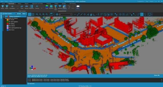
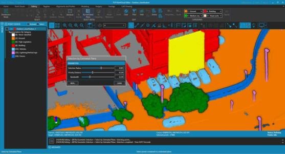
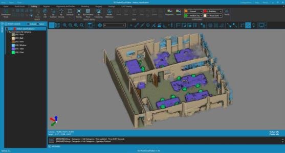
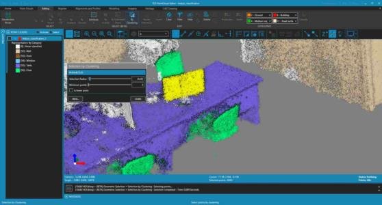
    The most notable has been the advanced classification and selection of point clouds through the use of machine learning algorithms, making it possible to segment and classify points from both indoor and outdoor scenes with remarkable accuracy. This facilitates the identification of relevant elements.

    What benefits or objectives have we set out to achieve with our applications so that they can then bring added value to the end user?

    The goal of integrating AI into our tools is not simply to innovate for the sake of innovation, but to develop practical and valuable solutions for industry professionals. These are some of the key benefits we are looking for:

    Minimize human error: by automating tasks such as data classification, the margin of error is significantly reduced.

    Optimize work times: Workflows become more efficient, allowing greater agility in projects with large volumes of data.

    Raise the quality of digital models: Better accuracy in data processing generates more reliable 3D models, essential for project planning and execution.

    Facilitate decision making: With better organized and presented data, technical teams can act more confidently and effectively.

    Reduce operating costs: Automation and accuracy contribute to more efficient use of resources.

    Conclusion

    At Aplitop, we continue to work to bring the advantages of Artificial Intelligence to all our solutions. This evolution is part of our ongoing commitment to R&D and the future of the industry. We are convinced that these improvements will not only transform the way we work, but will allow our users to be one step ahead in every project.

    Links of Interest

    🔗 Aplitop Research Lines

    🔗 tcp PointCloud Editor: AI-Powered Point Cloud Classification

     🔗 tcp PointCloud Editor Product Page


  • tcpMDT 25 for progeCAD Professional

    tcpMDT 25 for progeCAD Professional

    The new version of tcpMDT 25 for progeCAD Professional is now available.

    When combined with tcpMDT, users can access enhanced features, including the ability to generate digital terrain models, create contour lines, and obtain longitudinal and transverse profiles. Additionally, the software allows for the calculation of excavation and backfill volumes and provides 3D visualizations of terrain. It also facilitates the design of horizontal and vertical alignments, the definition of cross-sections, and the creation of utility networks, such as water, sewer, and stormwater systems.

    This option is available free of charge to all users with current maintenance.

    Links of Interest

    🔗 New features of tcpMDT 25

    🔗 Product page progeCAD

  • tcpMDT 25 for AutoCAD® 2026

    tcpMDT 25 for AutoCAD® 2026

    The new version of MDT 25 for AutoCAD® 2026 is now available. Combining tcpMDT with this software will help you improve the performance of your surveying projects.

    Support for AutoCAD® 2026 is free for all users with a current maintenance contract.

    Links of interest

    🔗 What's New in tcpMDT 25

    🔗 What's New in AutoCAD® 2026

  • tcp PointCloud Editor: AI Powered Point Clouds Classification

    tcp PointCloud Editor: AI Powered Point Clouds Classification

    What is tcp PointCloud Editor?

    tcp PointCloud Editor is an AI-powered point cloud software for surveying, engineering, architecture, and design. It enables 3D modeling and processing point clouds from fixed or SLAM scanners, LiDAR, photogrammetry, and mobile applications.

    What are the latest features?

    Below, we share a selection of the main new features of tcp PointCloud Editor, mainly focused on point classification using artificial intelligence:

    🆕 Automatic AI-based classification for indoor and outdoor scenes (1)
    🆕 Advanced point selection by estimated plane, neighborhood and grouping (1)
    🆕 New integrated help system
    🆕 Opacity control of panoramic images
    🆕 Simultaneous import of multiple models and image elements

    (1) These functions are provided as beta. See conditions in the license agreement.

    For more information, you can refer to the change history document.

    Useful links

    🆕 New tcp PointCloud Editor Playlist

    🔗 tcp PointCloud Editor Product Page

    🔗 Promotional Video of tcp PointCloud Editor

    🔗 Request a Quote for tcp PointCloud Editor

    🔗 Download the Demo of tcp PointCloud Editor

  • Partnership with General Laser

    Partnership with General Laser

    Aplitop is thrilled to announce its new collaboration with General Laser, a leading manufacturer of advanced sensors and robotic technologies.

    What is General Laser?

    General Laser is a European manufacturer of advanced sensor and robotic technologies based in Vienna, Austria. It offers a wide range of products, including RTK GNSS receivers, Lidar scanners, GIS mapping kits, and autonomous robots for inspection and security. The company excels in providing high-precision, real-time solutions for applications in construction, precision agriculture, oil and gas exploration, and infrastructure protection.

    Compatible Applications

    Through this collaboration, we have seamlessly integrated two applications from our ecosystem:

    🔵 tcp PointCloud Editor: This advanced point cloud processing software allows users to effectively manage point cloud data, specifically sourced from GLidar, General Laser’s handheld LiDAR scanner.

    🔵 tcpGPS for Android: Our field application works in conjunction with GLRM, General Laser’s GNSS receiver, to conduct precise topographic surveys and stakeout tasks. This application empowers field professionals by enhancing data accuracy and streamlining survey processes, ultimately leading to higher efficiency in project execution.

    Useful Links

    We share some links that you may find useful to learn more about this collaboration.

    🔗 tcpGPS for Android™ Product Page

    🔗 tcp PointCloud Editor Product Page

    🔗 General Laser Official Website

  • Availability of tcpMDT 25

    Availability of tcpMDT 25

    From Aplitop, we inform you that tcpMDT 25 is now available. This new version includes more than 100 new features and improvements, which you can consult in the following document: New features and improvements of tcpMDT 25.

    What should I take into account before upgrading?

    1️⃣ Prerequisites: Before installation, it is very convenient to check that the equipment meets the minimum hardware and software requirements.
    2️⃣ Compatibility: It is not necessary to uninstall the previous version of MDT, as it can coexist with MDT 9 on the same computer.
    3️⃣ Upgrade access: It is necessary to be registered in the Private Client Area.

    Availability per User

    🔵 Users with maintenance: We are beginning to roll out the updates. Watch your email for instructions on how to access the private area. If you are not already registered, you will need to fill out the following form and attach the necessary information so that we can register you: Customer Registration Form. Once submitted, we will email you within a few days to confirm that your registration has been successful.
    🔵 Users of old licenses: You can consult the advantages of contracting maintenance or request a quote for an upgrade.
    🔵 New users: They can request a quote.

    Resources of Interest

    Below, you will find some resources that will be updated over time, such as videos.

    📁 tcpMDT 25 Playlist

    📁 Datasheet of tcpMDT 25

    📁 User Manual of tcpMDT 25

    We recommend that these operations be carried out through our authorized distributors.

    If you have any questions about tcpMDT 25, you can contact us through the Contact Form.

  • Top 5 Major Pain Points in Surveying and Civil Engineering Projects

    Top 5 Major Pain Points in Surveying and Civil Engineering Projects

    As software developers, our goal is to create solutions that respond to the real needs of professionals. In this article, we will explore the challenges faced by surveying and civil engineering projects and how tcpMDT 25 can offer significant help in overcoming them.

    Topographic data is essential for many industries, such as surveying and geodesy, construction, architecture, and civil engineering. However, their management and use present several challenges that need to be addressed effectively.

    Here we share 5 pain points that professionals and companies face in surveying and civil engineering projects

    1. Complex topographic surveys

    One of the biggest challenges in surveying projects is the management of the points measured in the field with a wide variety of data of a very diverse nature.

    2. Big Data Management

    Managing large volumes of topographic data can be overwhelming and error-prone, especially when using multiple data sources.

    3. Modeling and Analysis of the Terrain

    Creating accurate terrain models and performing detailed analyses can be a complex and time-consuming process without the right tools.

    4. Infrastructure Design and Planning

    Infrastructure design and planning require precise integration of topographic and engineering data, which can be complicated and error-prone.

    5. Quality Control and Construction Supervision

    Ensuring the quality and supervision of the work is crucial for the success of any civil engineering project. However, this can be challenging due to the complexity and scale of the projects.

    How can tcpMDT help you overcome those challenges?

    Our tcpMDT 25 software is a modular application that is installed as a complement to the main CAD software on the market. It is easy to learn and contains a set of tools ideal for overcoming the main challenges presented in the surveying, civil engineering and construction industry.

    It has different modules that can help you as much as possible with your projects, these are the following:

    tcpMDT Standard

    It has import tools of various origins such as GNSS, total stations, point clouds, cartographies or digital models, WEB map servers, GIS, etc. allowing a wide range of generic formats of point lists, both customizable and standardized such as LAS, Shape, KML or LandXML that can be combined in the same project.

    Likewise, the effective management of codes in topographic surveys allows the data taken in the field to be represented automatically, saving processing time in the office and facilitating the drawing work to obtain the final cartography. 

    After importing the data, a wide range of utilities are available for data processing, at points, break lines, and surfaces, allowing fast and efficient editing.

    Finally, the cartography obtained can be treated in 2D or 3D, analyzed by bending, longitudinal, or transverse profiles, and generate verification reports or summaries of volume differences, with the possibility of also obtaining maps of heights, slopes, or virtual routes of the terrain.

    tcpMDT Professional

    It simplifies the design phase of civil engineering projects, both in linear road works and in earthworks or earthworks.

    Both the definition and editing in plan and elevation, as well as the creation of standard sections are simple to implement for the definition of a road. After that, obtaining the future modified land is easy to analyze and quantify, as well as extracting information from it for future stakeout work during the execution and control phase of the work.

    Likewise, in earthworks, earthworks, or pond projects, tools are available that allow the terrain to be modeled, and various solutions to be analyzed to minimize costs.

    tcpMDT Surveying

    It allows the management of data obtained by classical topography, with great calculation capacity for radiation, direct/reverse intersections, trigonometric and polygonal leveling and compensation operations.

    On the other hand, it offers the possibility of performing conversion operations between both global and local coordinate systems.

    tcpMDT Photovoltaic

    This application is suitable for calculating the earthworks in the implementation of photovoltaic parks. It has advanced features so that it is capable of calculating and correcting the different constraints associated with solar trackers, such as nominal clearance, maximum longitudinal and transverse slopes, jump between trackers, etc.

    It has the possibility of generating multiple types of reports both on volumes and media analysis, constraints, and power calculations…

    Additionally, it is possible to make a 3D representation of the project as well as export it to BIM.

    Helpful Resources

    If you want to know more about tcpMDT 25 and its different modules, click on the following links:

    🔗 tcpMDT Standard

    🔗 tcpMDT Professional

    🔗 tcpMDT Surveying

    🔗 tcpMDT Photovoltaic

  • Discover Aplitop's Support Center

    Discover Aplitop's Support Center

    At Aplitop, technical support is one of the pillars of our brand. We want to make the user part of our team and provide an optimal experience. After years of work, and being aware of the real needs of Surveying, Civil Engineering, and Construction professionals, we have developed a complete Support Center to help you every step of the way. Here is a detailed guide on how to get the most out of this resource.

    What is the Aplitop Support Center?

    The Aplitop Support Center is an online platform designed to provide technical and administrative support to users of Aplitop products. From license activation to technical troubleshooting, this center offers a wide range of resources and tools to facilitate the use of Aplitop software.

    Main Features of the Support Center

    🔵 Commercial Chat: Available for all users who have questions about purchasing or upgrading our applications, license types, modules, maintenance contracts, etc.
    🔵 Support Chat: Exclusively for customers with active maintenance. Get expert help to solve technical issues.
    🔵 Support Form: Available to all users, you can ask questions, make suggestions, or report issues. Submit details and our team will help you.
    🔵 Remote session: Our support team has requested a remote session to help you troubleshoot specific technical issues.

    How do I access the Support Center?

    Accessing the Aplitop Support Center is very easy. On our website, click on the "How can we help you?" button, or in the menu, click on Support > Support Center. You can access it by clicking here: Go to Support Center.

    Conclusion

    Aplitop Support Center is a new tool that will give you the assistance you need to get the most out of your software. Feel free to explore all the features it offers.

    Other Interesting Links Related to Support:

    🔗 Help Center

    🔗 Benefits of the Maintenance Contract

  • TcpGPS for Android™ compatible with SOUTH

    TcpGPS for Android™ compatible with SOUTH

    The Aplitop team is pleased to announce our collaboration with SOUTH.

    We have been working to empower surveyors by seamlessly integrating our tcpGPS for Android™ field surveying application with South Receivers, such as South G4.

    To learn more about this exciting collaboration, we invite you to explore the links below:

    🔗 TcpGPS for Android™ Product Page

    🔗 Configuration of South GNSS Receivers with tcpGPS for Android™

    🔗 South Official Website

  • tcpGPS for Android: Inaccessible Point Measurement with Distance Meter

    tcpGPS for Android: Inaccessible Point Measurement with Distance Meter

    What is tcpGPS for Android™?

    tcpGPS is a field application for data acquisition and stakeout of plots, urban areas and infrastructures with GPS/GNSS receivers. It runs on smartphones and tablets with Android operating system.

    What are the highlights of the latest update?

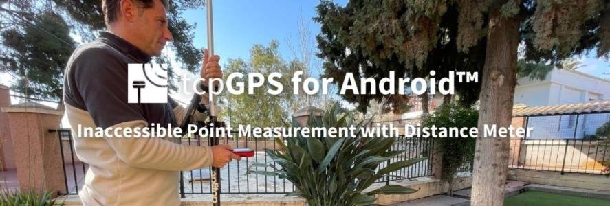
    🆕 New feature to measure using a connected Distance meter on COGO functions 🎥 Watch Video

    🆕 Compatibility with LEICA Laser Distance meters (DISTO D1, DISTO D110, DISTO D2, DISTO D510, DISTO D810 Touch, DISTO S910)

    🆕 Added a button on the observation points dialog to remove all epochs outside of stablished tolerances for the point average

    For more information, you can access the change history document.

    Want to know more?

    If you want to learn more about this new version, below, we share links of interest:

    🔗 Request quote for tcpGPS for Android

    🔗 Request demo of tcpGPS for Android

    🔗 Discover the product page of tcpGPS for Android